The cave stands out due to its length of 113 metres, which is highly unusual for a travertine cave.
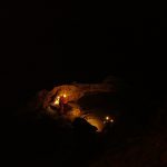
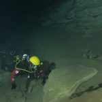
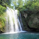
The Miljacka III cave (also called the Cave under the waterfall) was accidentally discovered in 1988 when examining the banks of the Krka River under the travertine barrier at the Miljacka waterfall. It is positioned within the course of the Krka River. The entrance to the cave is at the base of a 7.2 metre tall travertine cliff of polygenetic origin, formed from the alternation of accumulation and denudation phases. The cave stands out due to its length of 113 metres, which is highly unusual for a travertine cave. It is 6.6 metres deep. It was formed by the expansion of what were initially fissures in the travertine after it solidified as rock. It can only be accessed by diving. During periods of high water, entrance is not possible. The hydrological conditions are also interesting in the cave, for in this section, the water flows both through the cave and along the surface in the Krka River, so it flows at two different levels.
In terms of its morphology, the Miljacka III cave is a simple cave with only one main channel and no branches. The formation of the cave was based on the fracture systems caused by the breakage of travertine, and shares the same orientation as the bed of the Krka River. The cave is a constant source, with water appearing in it both as percolating water and as dripping water. In the channel expansions, there are abundant depositions of speleothems in the form of stalactites, flowstone and speleothem crusts on the channel walls.
The cave was formed in travertine deposits (an elongated travertine body), and is likely of Holocene age, and more precisely lies in the zone of contact between the travertine and base rock upon which the travertine was deposited. The rock base is visible in parts of the entrance, sporadically throughout the cave and at the end of its channel. In the rock, micro-relief forms are visible, such as troughs and eddy pots, created by erosion. The main part of the cave is formed in travertine, as it is softer than the base rock and therefore more strongly affected by erosion. This initiates paragenetic processes and results in mechanical wear and a widening of the channels, as seen by the predominantly travertine system of accumulated fluvial materials covering the floor of the cave. In addition to erosion, the channel has also been shaped by cave-ins, with karst rock and large blocks of travertine also found in the sediments on the floor. Research of this sediment confirmed that large particle sediments are deposited on the cave floor, mostly sands with varying ratios of gravel and silt fractions. The mineral composition of the sediments has shown that the primary mineral is calcite, followed by quartz, with traces of dolomite and mica.
In the Miljacka III cave, erosional remnants of sediments are found along the entire profile of the channel (on the floor, walls and ceiling). These sediments were likely deposited during phreatic (submerged) conditions in the geological past of the cave. Since they are somewhat eroded, it can be assumed that they were deposited in conditions different to those today. The phreatic sediments of the Miljacka III cave were also deposited onto the stalactites that formed under dry air conditions, so it can be concluded that this cave has undergone numerous stages of alternating dry air and submerged conditions.
Research of the laminate cave sediments and stalactites in the submerged part of the cave channel in Miljacka III indicated the recrystallisation of speleothems following the circulation of pore water, presenting a problem in dating these samples, as the U-Th dating method would not be able to successfully determine the age of the stalactites due to this recrystallisation.
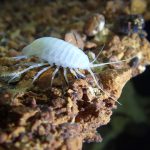
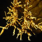
Unusual organic, white to yellowish formations have been discovered in the Miljacka III cave, attached to the submerged cave walls. Analysis of these formations indicated that these are anthozoan type of colonies likely containing more than 30 bacterial species.
Photograph: Nenad Buzjak