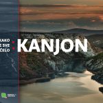
Cut deep into the North Dalmatian karst plateau, the Krka River Canyon is special for many reasons, not just its beauty.
The world’s largest and best known canyon is the one in Arizona, that was carved out of stone by the Colorado River over millions of years – the Grand Canyon. The second deepest canyon in the world, and the deepest in Europe, is the Tara River Canyon in Montenegro. Cut deep into the North Dalmatian karst plateau, the Krka River Canyon is special for many reasons, not just its beauty. It is the youngest part of the landscape. The remainder is raised travertine barriers, which has given this area a unique appearance that is recognisable worldwide.
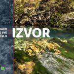
To simplify geomorphological factors, we could say that a crack was formed in the Earth’s crust from the Dinara Mountains to the sea, where the surface waters flowed. However, the formation of the Krka River Canyon was the result of much more complex processes and tectonic movements. The cutting of the river into the plateau was monophasic, meaning that the canyon was not formed gradually over time, but all at once, as seen by the lack of river terraces along its course. The initial relief was the first factor to modify the original watercourse, and then the watercourse was determined by tectonic movements and the composition of the rock. This is seen in the breakage lines and light bending of the land that favoured the erosion action of the river. At that time, the Krka had more water and carried more rock downstream, blazing its path towards the sea, which due to lower sea levels was much farther offshore than the present day coastline. This is why we can follow the ancient Krka Canyon all the way to the southern coast of the island of Zlarin in the Šibenik archipelago. All these events took place during the glacial period (Upper Pleistocene – Würm, 40,000 to 170,000 years ago).
The Early Holocene followed the Würm glaciation on the geological timescale. During this era, the glacial ice massively melted, raising the sea level by 120 to 125 metres. This took place about 18,000 years ago, when the Krka River estuary was formed from Šibenik to Prukljan Lake. Further increases in sea level brought the sea right up to Skradinski buk. Today, the Krka River estuary is considered to begin under the Skradinski buk waterfall and extends southwards to the Fortress of St. Nicholas, 22 kilometres downstream. Within the estuary lie the towns of Skradin and Šibenik, and picturesque places such as Zaton and Raslina, sites where notable cultural and historical heritage was formed in unity with nature over a thousand years. During this time, the Krka has flown on the sea surface. How this eternal intertwining of freshwater and sea water will change in the future, will be seen in the Earth’s geological future. Numerous scientists believe that the interglacial period has not yet reached its maximum and that sea levels will continue to rise, caused by the anthropogenic activities and the greenhouse effect. As we sail upstream from Skradin to Skradinski buk, we should all consider how, for the first time in the many eons of the Earth’s long history, humans are now affecting natural processes. Because the water remembers.